FishTrack provides saltwater anglers with everything they need to find fish. The FishTrack app offers free cloudfree sea surface temperature (SST) charts, global satellite imagery and marine weather forecasts – all in one layered tool.
With FishTrack you can:
- View the latest SST, chlorophyll and true color satellite imagery
- Overlay bathymetry, ocean currents and sea surface height
- Save waypoints to mark fishing spots and catches
- Create routes to plan a trip and view distances and headings
- View marine weather forecasts and tides/solunar tables
- Save fishing chart imagery for offline use
- View your current location both online and offline
Don't fish blind! FishTrack helps you plan a productive trip offshore. Burn less fuel and find fish faster.
We want to hear from you! Submit your questions or comments through our app to let us know what you think. If you'd like to speak directly with our customer service team, please e-mail us at: support@fishtrack.com.
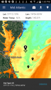
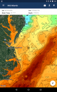
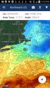
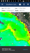
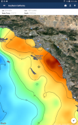
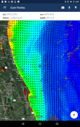
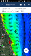
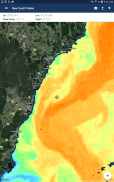
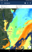
FishTrack memberikan pemancing air asin dengan segala yang mereka butuhkan untuk mencari ikan. The FishTrack app menawarkan cloudfree suhu permukaan laut (SST) grafik gratis, citra satelit global dan prakiraan cuaca laut - semua dalam satu alat berlapis.
Dengan FishTrack Anda dapat:
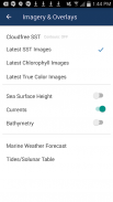
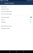
- Lihat SST terbaru, klorofil dan citra satelit warna yang benar
- Overlay batimetri, arus laut dan permukaan laut tinggi
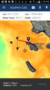
- Simpan waypoints untuk menandai tempat memancing dan menangkap
- Buat rute untuk merencanakan perjalanan dan melihat jarak dan judul
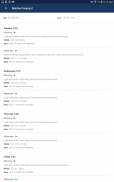
- Lihat ramalan cuaca laut dan pasang / tabel solunar
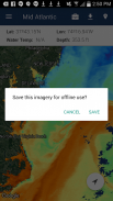
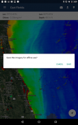
- Simpan memancing citra grafik untuk penggunaan offline
- Lihat lokasi Anda saat ini baik online dan offline
Tidak ikan buta! FishTrack membantu Anda merencanakan perjalanan produktif lepas pantai. Membakar lebih sedikit bahan bakar dan mencari ikan lebih cepat.
Kami ingin mendengar dari Anda! Mengirimkan pertanyaan atau komentar melalui aplikasi kami untuk memberitahu kami tahu apa yang Anda pikirkan. Jika Anda ingin berbicara langsung dengan tim layanan pelanggan kami, silakan e-mail kami di: support@fishtrack.com.
FishTrack provides saltwater anglers with everything they need to find fish. The FishTrack app offers free cloudfree sea surface temperature (SST) charts, global satellite imagery and marine weather forecasts – all in one layered tool.
With FishTrack you can:
- View the latest SST, chlorophyll and true color satellite imagery
- Overlay bathymetry, ocean currents and sea surface height
- Save waypoints to mark fishing spots and catches
- Create routes to plan a trip and view distances and headings
- View marine weather forecasts and tides/solunar tables
- Save fishing chart imagery for offline use
- View your current location both online and offline
Don't fish blind! FishTrack helps you plan a productive trip offshore. Burn less fuel and find fish faster.
We want to hear from you! Submit your questions or comments through our app to let us know what you think. If you'd like to speak directly with our customer service team, please e-mail us at: support@fishtrack.com.